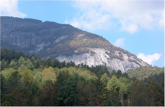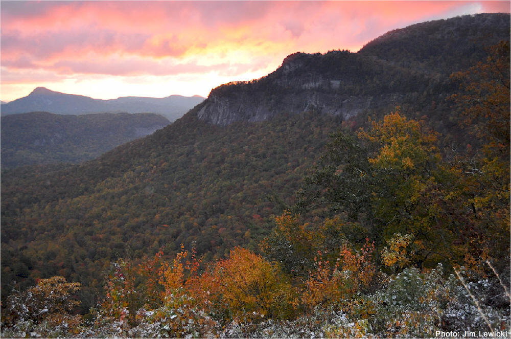
.Whiteside Mountain, Hwy. 64 between Highlands & Cashiers NC
.
Hiking Whiteside Mountain -
Highlands Newspaper Article
.
Highlands
Area Fishing Spots
.
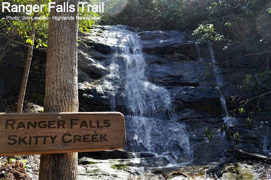
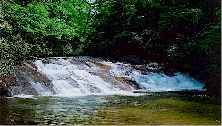
Ranger Falls
- The Trail Along
Skitty Creek
Connects
Cliffside Lake
To The Old Flat Mtn. Ranger Station
HIGHLANDS & CASHIERS AREA WATERFALL VIDEOS
Bridal Veil Falls | Dry Falls | Bust Your Butt Falls | Cullasaja Falls | Glen Falls | Sequoyah Falls | Ranger Falls
Iron Bridge | Sliding Rock Cashiers | Silver Run Falls | Whitewater Falls | Rainbow Falls | Bear Wallow Falls
Looking Glass Falls | Sliding Rock Brevard | Tallulah Gorge Falls | Lake Toxaway Falls
Holcomb Falls | Ammons Falls | Overflow Creek Falls | 3 Forks Overflow Creek Falls | W. Chattooga Head
Fly Fishing - Chattooga River - Above Iron Bridge - Video
Rock House Falls | King Creek Falls | Spoonauger Falls
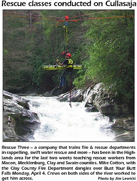
Caution: Be Prepared & Careful
.
.
Our Volunteers Risk Their Lives To Save Yours
Cullasaja River Fishing Map & Videos
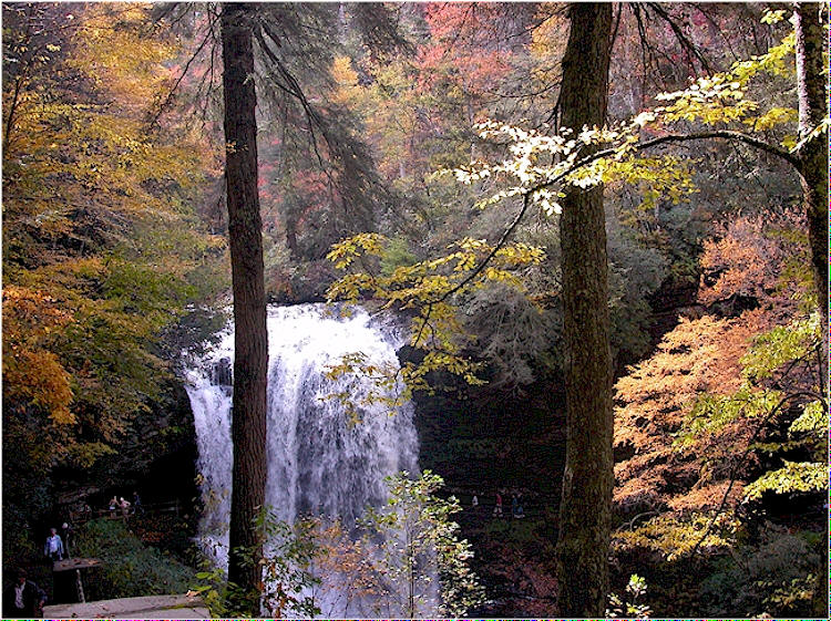
Dry Falls
One of
North Carolina's Best - Only 2 Miles From Highlands
-
Photo: Jim Lewicki
Cullasaja River
Fishing Map & Videos
|
Highlands Area Hiking Trails
Green Text =s Highlands Most Popular Hiking Trails
Sunset Rocks: 1.2 miles (round trip). Trail head: Horse Cove Rd., across from the Highlands Nature Center. Features: A rock outcropping overlooking Highlands and Horse Cove; trees marked and identified as part of the Town of Highlands "Highlands Trees" project.
Satulah Mountain Summit: The trail is a short hike down an old road bed to the summit, which is 4543 ft. Excellent panoramic views. Distance Aprox. 1/2 mile one way.
Whiteside Mountain:
2
miles (round trip). Trail Head: Whiteside Mt. parking area. Features: This
moderate loop trail offers spectacular views from a high ridge top, 2,100'
above the valley floor. Whiteside Mt. (4900') has the highest sheer cliffs
in the Eastern US (400 - 750').
Devil's
Courthouse: accessed from the Whiteside Mountain Trail.
Horse Cove Poplar Tree: 100 yards from the Trail Head off Rich Gap Rd. Features: Large yellow tulip popular, the second largest tree in the state and third largest in the East.
Glen Falls: 1.4 miles (one way; 15 min. to first falls). Trail head: Glen Falls parking lot. Trail end: Forest Service Rd. (79C) in Blue Valley. Features: Three cascading waterfalls and a beautiful stream. One of the advantages of this trail is that you can return after seeing the first or second waterfall, and still have an enjoyable walk.
Chinquapin Mountain: 3.2 miles (round trip). Trail head: Glen Falls parking area. Features: Numerous stream crossings and several views from Chinquapin Mt. (4,160') into Blue Valley at vistas along the trail. Access also available off of NC106 approximately 3 miles from Highlands.
Cliffside Lake Recreation Area: There are numerous hiking trails in this area, including an interpretive loop trail describing shrubs and trees along the Cliffside Vista Trail. The half-mile loop around the lake offers hikers an easy walk that is quite level. Cliffside Vista Trail accessed from the road before entering the parking area. Cullasaja River Fishing Map Skitty Creek Trail To Cliffside Lake Cullasaja River Map
Chattooga Loop Trail: 2 miles (round trip). Trail head: Horse Cove Rd. Features: A pleasant walk through the woods and then along the river, ending with a spectacular view of rock formations from the Bull Pen Rd. Bridge, known as "The Iron Bridge." Google Map Location Chattooga Trail from Iron Bride Bull Pen Rd. to Whiteside Cove Rd. 6 miles.
Ranger Falls Trail: Accessed from Flat Mtn. Ranger Station off Flat Mtn. Rd. or Cliffside Lake Recreation Area.
Nature Center: Trails with interpretive arboretum features located across the street from Sunset Rocks in Highlands.
Rabun Bald
Area Peak 4,696 - This trail provides a
spectacular view of the tri-state area from an observation deck atop Rabun
Bald, Georgia's second highest point. The deck is constructed from
remnants of an old fire tower built in the 1930s. One of Georgia's rarest
birds, the raven, is frequently sighted. The ascent is extremely steep. 2
miles one way. Directions: From Highlands to Scaly Mtn., then just past
the post office take a left turn on Hale Ridge Rd. then a right on Bald
Mtn. Rd. & look for a US Forestry sign that indicates a left on Kelsey Mtn.
Rd. to the Trailhead.
Bartram Trail: Offers
many short or long hikes to spectacular vistas, such as Scaly Mt., Jones
Knob, and Whiterock Mountain. This
national recreation trail runs across the mountains of South Carolina,
Georgia and North Carolina. It stretches nearly 80 miles from Highlands to
Cheoah Bald, east of Robbinsville. Blazed in yellow in Nantahala National
Forest, the trail is named after William Bartram, a naturalist who roamed
the Southern woods in 1775.
Yellow Mountain - Shortoff MT: 3 miles (round trip) to Shortoff Mt., 9.6 miles (round trip) to Yellow Mt. trail head: Cole Gap on Buck Creek Rd. Features: A short easy hike to a view of Buck Creek area; Shortoff Mt. has views to the south; Yellow Mt. has views in all directions. The trail to Yellow Mt. is a difficult trail, traversing three of the area's scenic mountains, with many steep ascents and descents. Located off Buck Creek Rd.
Ellicott's
Rock Trails: 7 miles
each (round trip). Trail head: Bull Pen Rd. Features Ellicott’s Rock is
a rock embedded in the Chattooga River bank bearing the letters NC, carved
by surveyor Andrew Ellicott. He thought this to be the intersection of GA,
NC & SC. The actual point of the intersection is Commissioner's Rock,
bearing the symbol NC/SC 1813, 10 feet downstream. Directions:...take the
right fork, Bull Pen Road. Ellicott’s Rock trail starts There are 3 trails that lead to the Ellicott Rock; Bad
Creek, Ellicott Rock and the Chattooga River Trail. The Bad Creek Trail is
the easiest trail. The Bad Creek Trail begins at the Fowler Creek parking
area off of Bull Pen road
Whitewater Falls Trail: 1/2 mile (round trip). Trail head Whitewater Falls parking lot. Featuring Whitewater Falls the highest in the eastern U.S., 411 feet and is an easy walk on the paved trail.
The 3 Forks Trail: Begins at John Teague Gap and ends near the west fork of the Chattooga River. Hikers will encounter steep and rugged terrain. Exercise caution if you attempt to proceed down to the river on an unmaintained extension.
Points of Interest Before The Bartram & Chattooga River Trail On Hwy. 28
Notice: This is information only. To ensure an enjoyable hike, we strongly recommend you contact the US Forest Service at (828) 526-3765 or visit their office. They have additional information, maps and brochures. Please use caution; although these trails, waterfalls, and scenic areas are beautiful to see, they can be very dangerous.
Waterfalls
Green Text =s
Waterfalls Close To The Town Of Highlands Bridal Veil Falls:
This fall
cascades over US 64/28 3 miles from town. Cars drive under the 120 ft.
waterfall.
Bridal
Vail Falls Video |
Cullasaja
River Fishing Map
Bust Your Butt Falls:
On Hwy.64 / 6 miles from west of Highlands, NC.
Cullasaja Falls:
On Hwy.64 / 9 miles from town, it is one of the most Picturesque falls in
North Carolina. It is a 250 ft cascade.
Cullasaja
River Fishing Map
Dry Falls
On US 64/28, 4 miles from Highlands. A pleasant
walk from the highway, the path goes behind the 75 ft. waterfall.
Cullasaja
River Fishing Map
Lake
Sequoyah Falls:
Located
off US 64/28 west, 2.5 miles northwest of Highlands on the Cullasaja
River. The Sequoyah Dam is at the head of the falls. There are 18 small
falls within a quarter mile paralleling US 64/28.
Cullasaja
River Fishing Map Glen Falls:
Located off a
dirt road 3 miles south of Highlands on 106S. The turn-off is marked by a
U.S.F.S. sign. Glen Falls is composed of a series of 3 large falls
dropping approximately 60ft. each on the east fork of Overflow Creek in
the Blue Valley area. The one-mile foot trail down to the falls is steep.
Glen Falls
Video
Ranger Falls:
from
Cliffside Lake or Flat. Mtn. Ranger Station.
Iron Bridge Falls:
Horse Cove Rd. Left on Bull Pen Rd. The bridge crosses the Chattooga. Bull
Pen Rd. continues onto Hwy. 107. -
Iron Bridge Fly Fishing
Rock House Falls:
40ft.
located in
Blue Valley
High Altitude
Trout Fishing Map & Videos Close To Highlands, NC
Silver Run Falls: A 30-foot waterfall spills into a pool of water. Off NC 107, 4.1 miles south of Cashiers. Park in pull-off on left & take a short, easy trail to base of falls
Whitewater Falls: Aprox. 28 miles from Highlands, these falls are the highest in the eastern US at 411 ft. A pleasant 60 minute drive, many visitors enjoy driving through Horse Cove and crossing over the Chattooga River on their way to Whitewater.
Holcomb Creek Falls: This trail begins at the intersection of Hale Ridge Road (Forest Service Road 7) and Overflow Road (Forest Service Road 86) and follows a short loop to its end on Hale Ridge Road. The trail passes Holcomb Creek Falls and Ammons Creek Falls, where there is an observation deck.
Ammons Creek Falls: This trail begins at the intersection of Hale Ridge Road (Forest Service Road 7) and Overflow Road (Forest Service Road 86) and follows a short loop to its end on Hale Ridge Road. The trail passes Holcomb Creek Falls and Ammons Creek Falls, where there is an observation deck.
Gorges State Park - Rainbow Falls - Bearwallow Falls
Scenic Overlooks
Blue Valley Overlook - Located 3 1/2 miles SW of Highlands on NC Hwy. 106s. Looking from Blue Valley Overlook PICTURES
Osage Overlook - Hwy. 106s across from Bartram Trail entrance, the view from this vantage is of Scaly and Osage Mountains. PICTURES
Whiteside Overlook - Located 5 1/2 miles from Highlands on Hwy.64e. Looking out over Whiteside, you will be faced with the majesty and austerity of the mountains. PICTURES
Camping
Van Hook Glade
@
Cliffside Lake - 4 Miles West Of Highlands NC
Ammons Branch Primitive Camping Area
Blue Valley Primitive Camping Area
Burrell's Ford
Campground
Ellicott’s Rock
Wilderness
Fly Fishing
Types Of Trout Caught In The Highlands Area & License Info.
Best High Altitude Trout Fishing In The Southeast - Cullasaja River Highlands, NC
Fish Cashiers & Jackson County North Carolina
Fly Fishing The Chattooga River Iron Bridge Area Between Highlands & Cashiers
Fish The West Fork Of The Chattooga River
Lake Glenville Fishing & Boat Ramp Access
Walhalla SC Fish Hatchery Hwy. 107
The upper section of the Chattooga River
is located in Jackson County on the Highlands Ranger District where it
flows into Georgia and South Carolina.
The Chattooga River flows thru the Ellicott Wilderness area and is
classified as a Wild and Scenic River. Anglers enjoy the trout fishing
that the Chattooga has to offer. Brown
trout are abundant, and rainbow trout are also occasionally caught in the
Chattooga River. Access:
From Franklin follow Hwy 64 East thru the town of Highlands down
Bull Pen Road thru the Horse Cove community.
Bear right onto FS Road 1178 (Bull Pen Road).
Follow FS1178 till you get to the iron bridge at the Chattooga
River. Camping:
There are only Primitive camp sites in the Ellicott Wilderness area
along the Chattooga River.
This means that there are no facilities and you should only leave foot
prints on the wilderness trails. Season: Fishing in the Chattooga River is open all year around. The Upper Chattooga in Jackson and Macon counties upstream of the SR 1100 bridge is managed under Wild trout regulations In all wild trout waters the minimum length limit is 7 inches and the creel limit is 4 trout per day. Only artificial lures with one single hook may be used. Below the bridge, Wild trout/ natural bait regulations apply (artificial lures or natural baits, except live fish, and using only single hooks; minimum length limit is 7 inches and the creel limit is 4 trout per day.)
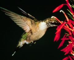
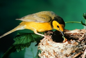
Bird Watching Highlands NC An Official Bird Sanctuary
Did you know that North Carolina's national forests are a summer home for more than 63 kinds of neotropical birds, such as the red-eyed vireo and indigo bunting? Neotropical migratory birds account for 340 of the 600 species of birds that breed and nest in North America. These birds migrate each fall to warmer climates in tropical regions of Mexico, Central America, South America, and the Caribbean. A sure sign of spring is the return of these colorful, transcontinental travelers, which awaken us with their songs. In comparison, "resident" birds, such as the northern cardinal, hang around all year. Some migrants, like the American robin, travel short distances to spend the cold winter months in warmer areas of the United States. The annual migration of North America's neotropical migratory birds is
a biological wonder. It's hard to imagine that a blackpoll warbler that
nests in the Northern States, makes an 86-hour, 2,300-mile nonstop flight
across the Atlantic. These tiny birds must double their body weight in the
late summer and early fall to build up enough body fat to make the
long-distance flight.
With the advent of spring, most neotropical birds return to the place where they were born. The Southern Appalachians are a popular nesting ground for these birds, because the area provides some of the largest blocks of mature forest in the Eastern United States. As part of the Southern Appalachians, North Carolina's national forests offer the perfect habitat for a diversity of neotropical migratory birds.
With large blocks of forest and unique combinations of elevation, topography, climate, soil, and geology, North Carolina's national forests provide a huge sanctuary for many of these birds. The national forests are managed not only for large tracts of mature hardwood forest, but also for grassy openings, brushy thickets, young forests, and high-elevation spruce-fir forests. These habitats provide homes and food for 160 bird species.
|
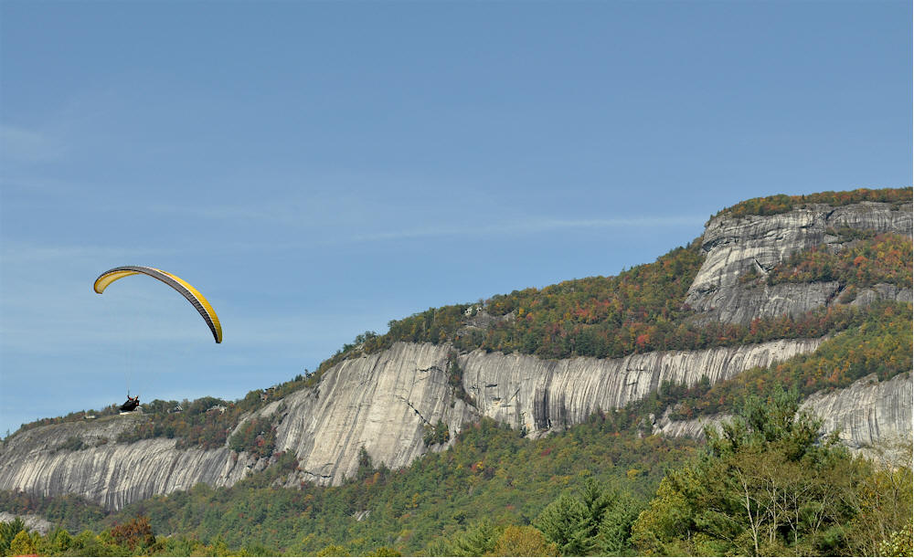
Para-Sailing
Whiteside Mountain Cliffs - Fall 2009 - View From Whiteside Cove Rd.
Photo: Jim Lewicki
-
Copyrighted 2017
If your looking for unique scenic properties - Contact our local realtors today - They can help you find the perfect location.
.